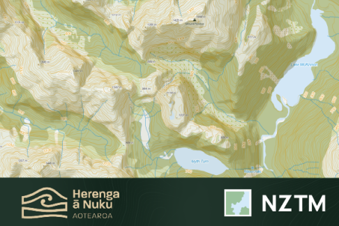
Topographic basemap
Download Pocket Maps with the new topographic basemap
Download Pocket Maps via the Apple App Store for iOS or Google Play Store for Android.

Pocket Maps Topographic basemap is now available to use on iOS and Android devices.
What is it?
Pocket Maps Topographic (v1) is a new basemap for Pocket Maps, that allows users to take a topographic basemap offline. This basemap is based on the LINZ Topo50 basemap and uses the latest LINZ topographic datasets.
Why?
Since its release, Pocket Maps users have consistently asked for one thing: offline topographic maps. Until recently, this option was not possible due to a range of technical hurdles. These hurdles are now overcome by the Herenga ā Nuku team, after authoring a new offline capable topographic basemap, specifically designed for use with Pocket Maps.
We hope that by providing this topographic map for offline use, people can get greater use from Pocket Maps when using it in the outdoors, be aware of public access areas and navigate them safely.
Data sources
The source data for this basemap is the majority of the datasets used by LINZ to create the Topo50 basemap series such as place names, contours, rivers, roads, building outlines, lakes, as well as New Zealand Geographic Board (NZGB) place names. The basemap also features huts and campsites provided by Department of Conservation (DOC). For landcover, this basemap uses the latest version of the Landcover Classification Database (LCDB) v5 to visualize different landcover types.
This basemap also uses the LINZ NZ National 8m DEM (Geographx, 2012) to show a single direction vector hillshade terrain layer underneath the basemap.
Update frequency
This basemap will be updated on a quarterly basis, in line with the quarterly LINZ Topo50 data update schedule.
Design
This basemap has been designed to mirror the design and cartographic style of LINZ’s iconic and well-loved Topo50 basemap series, where possible, with some minor differences here and there. The design follows accessibility design principles as much as possible. The classic LINZ Topo50 basemap will continue to be available on Pocket Maps (online only).
License
All source data listed above and the resulting basemap are licensed under Creative Commons Attribution International (CC 4.0) for re-use and redistribution, with attribution.
Data credits
Toitū Te Whenua | Land Information New Zealand, Manaaki Whenua Landcare Research , Department of Conservation (DOC), Geographx
Contact
If you would like to contact us about this basemap, feel free to reach out to the Herenga ā Nuku Geospatial Team via the email address below: GIS@herengaanuku.govt.nz
Disclaimer
This basemap is NOT the Topo50 map series published in both physical and raster tile form by Toitū Te Whenua Land Information New Zealand, and as such LINZ is not responsible for the authoring or representation of its contents. Any issues or feedback regarding this basemap should be passed directly to Herenga ā Nuku | Outdoor Access Commission in the first instance.
- Herenga ā Nuku | Aotearoa Outdoor Access Commission makes no express or implied warranties as to the accuracy or completeness of the data or information, nor its suitability for any purpose. Errors are inevitably part of any database and can arise by a number of means. This includes information supplied from other parties.
- The Commission makes no warranties or representations as to possible infringement upon copyrights or other intellectual property rights of others in the data or information.
- The Commission will not accept liability for any direct, indirect, special or consequential damages, losses or expenses howsoever arising and relating to use, or lack of use, of the data or information supplied.
- Take care when deriving conclusions from any data or information supplied.
- Any use of the data or information supplied should state when the data or information was acquired, and that it may now be out-of-date.
Download now
Download Pocket Maps via the Apple App Store for iOS or Google Play Store for Android.


