
Wenderholm to Stillwater
-
Walking
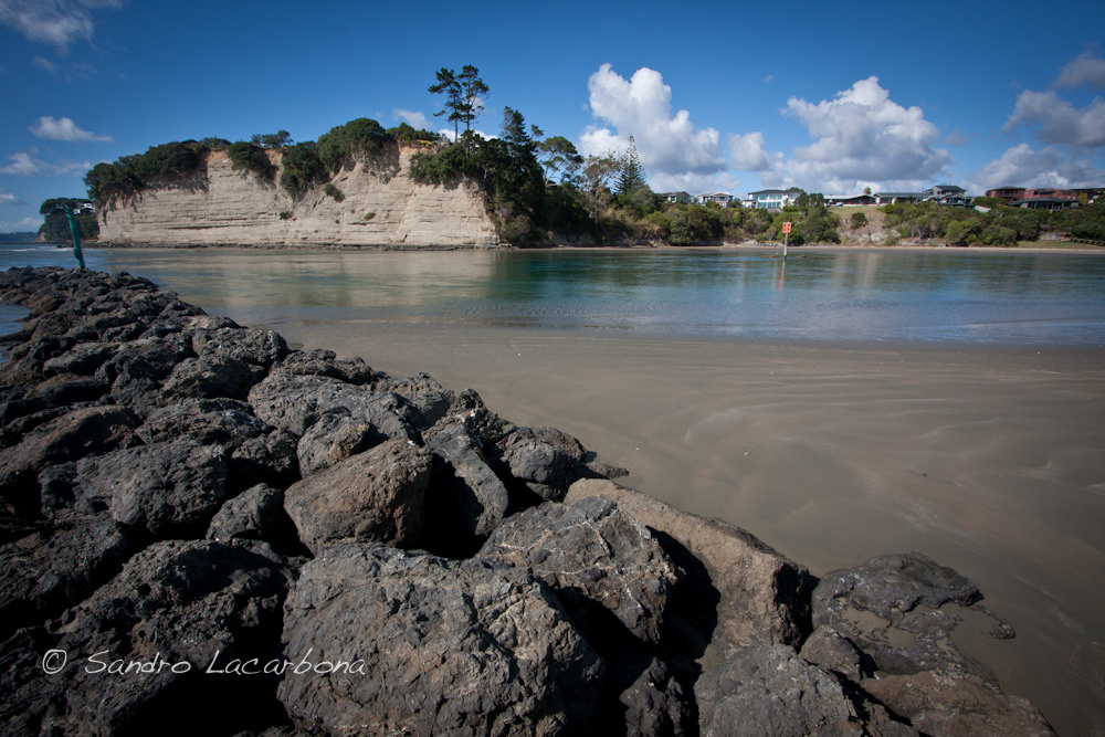
Te Araroa trail section: This section includes a low-tide walk and rock hop, and a fantastic view of the trail down Orewa Beach
Wenderholm to Orewa Estuary - 11.5km / 3hr
- Low tide route only
Requires a low tide - check tides at Niwa
From the Puhoi River boat ramp at Wenderholm Regional Park take the sealed road south-east through the carpark. Follow the signs for Walking tracks, through the gate into the Couldray House grounds. Continue to the right of the house to reach the park signboard. Turn left at the signboard and walk 200 m to join with the Perimeter Track. This is a loop track so arrows indicate both directions. Clockwise over the headland is the most picturesque and has great views. Cross the gravel road and head uphill on the Perimeter Track towards Kokoru Bay.
NOTE: Some Wenderholm tracks have been re-aligned and renamed since the Te Araroa maps were drawn. Map 28 does not accurately show the current route. Wenderholm Cliff Walkway has been replaced by the Perimeter Track and the clockwise Te Araroa route starts from the path to the right (south) of Couldray House
Exit the track by the Waiwera Bridge on the Hibiscus Coast Highway. Cross the bridge and head down Waiwera Road to the beach. Time your walk so that you reach here about half an hour before low tide.
At low tide, it is an easy walk and rock hop around rocks to Hatfields Beach. Beware of slippery rocks.
At the southern end of the beach, take the public walkway steps up to Ocean View Road and follow the walkway signs south via footpaths back out to the Hibiscus Coast Highway. Just over the hill to the south is Lookout Point and the most fantastic view down Orewa Beach – a great sight no matter what the weather.
Note: Optionally, you can avoid Lookout Point by walking along the beach and rocks from Hatfields to Orewa at low tide. This option, however, would bypass the elevated coastal views.
Continue down the hill and walk through Arundel Reserve to Orewa Beach. About 1.5km south is the Orewa Beach Shopping Centre. (Orewa Beach is approx 3km long in total).
Orewa Estuary to Stillwater - 13km / 3 hours
From the southern end of Orewa Beach, follow the path to the bridge over the Orewa River.
At the south end of the bridge, take the path next to the bridge and turn west underneath the bridge onto Te Ara Tahuna (The Orewa Estuary Cycleway and Walkway)
Follow Te Ara Tahuna approx. 2.5km to the intersection of Longmore Lane and Millwater Parkway then turn south for 1km.
Turn right/south at the intersection of Millwater Parkway and Silverdale Street. On your left is the Silverdale Centre with a selection of shops, including a supermarket, outdoors shop and pharmacy. To your right are multiple banks (with ATMs), fast food outlets, butcher and greengrocer.
Continue on Silverdale Street to the intersection with Hibiscus Coast Highway where an underpass takes you safely under the road, and onto Tavern Road (past the historic Wade Tavern), up the hill to Forge Road/East Coast Bays Road.
Turn south onto East Coast Bays Road and walk 2km to the intersection with Spur Road. Turn east onto Spur Road and walk 1.4km to where it leads into Duck Creek Road. Continue a further 5km on Duck Creek Road to the Stillwater Boating Club where the next track commences. This road is narrow and winding with poor visibility. Duck Creek Road will be bypassed when the PenLink road bridge is built, but that is a long time away. It is often possible to hitch from the top of Spur Road. Local residents, concerned about the safety of walkers on narrow Duck Creek Road, may offer lifts to hikers waiting at the top of Spur Road, km 558
Conditions
Potential hazards
- Vehicles on road or track Take extreme care on East Coast, Spur and Duck Creek Roads heading to Stillwater
- Poisons & traps at Wenderholm Regional Park
- Tides, waves & rivers - safer at low tide
No dogs allowed
How to get here
Northern Start: Wenderholm Regional Park, Hibiscus Coast
Southern End: Stillwater Boating Club, Stillwater
Transport
Accommodation
Waiwera
There is no accommodation in Waiwera - the options you have are Schischka campground in Wenderholm Regional Park (north) or hostel/motel/campground accommodation in Orewa (south).
Small bay before Hatfields Beach
- Trail Angel at km 545.5 Hatfields. We can offer a number of different accommodation options.
1) Free - Camping - Tent sites
2) Koha - Small cabin with bed and couch for up to 3 people.
3) Cottage - sleeps 6 to 8
Rate negotiable. James and Cynthia Mackenzie P: 021 756 593 E: james@seaforth.co.nz
We are on a 60 acre block of regenerating native forest on the coast and the trail runs along the beach in front of our property. see www.seaforth.co.nz
Camping on Hatfield Beach Reserve
- Single night freedom camping is permitted on the Hatfield Beach Reserve. Camper vans park on the seafront, but tent campers should use the large grass reserve on the inland side of the road. Preferably choose a location not immediately noticeable from the road. Toilets and water tap
Orewa
- Orewa Beach Holiday Park, 265 Hibiscus Coast Highway, P: 09 426 5832
Silverdale
- Silverdale Bed and Breakfast - 41 Whangaparaoa Rd, Silverdale (600m off the Te Araroa route) - Apartment - Studio - Caravan - P: 09 4211460 - E: Seaside_BnB@xtra.co.nz
Stillwater
- Feijoa Cottage - 389 Duck Creek Rd, Stillwater - Contact Jane on 021 037 5338. Set on a rural property in Stillwater, Feijoa Cottage is a fully self-contained home away from home. If you're walking the Te Araroa Trail and want a night of luxury in a comfortable bed, a nice hot shower, to cook up a yummy meal and do your washing - you'll be walking right past their door.
- Stillwater Motor Camp, which may be listed on FarOut, closed April 22nd 2024
Before Okura Crossing
- Dacre Cottage Historical Reserve, on the beach just before Dacre Point, is a convenient place to camp if the tide suits an early morning crossing. Dacre Cottage Management Committed have generously allowed Te Araroa walkers to camp outside the cottage. (No access to cottage buildings). Toilets and water (repaired 19 November 2024). Booking not required but please phone Pete Townend 027 452 9255 to confirm
Food And Supply
Waiwera minimart - 2 Waiwera Rd. Waiwera - P: 09 426 1470
Silverdale Centre - 61 Silverdale Street, Silverdale - P: 09 426 4716 - Includes Countdown Supermarket, pharmacy, outdoors store (Macpac), food outlets, The Warehouse, barber etc.
Track Elevation and Map

Total 1 photos. Click image above to view them all.
More information
Wenderholm Regional Park or contact the Auckland Council on P: 09 366 2000.
Before starting Te Araroa either as a through-walker of the whole country or a section walker, please register on Te Araroa website. Please also visit the website or download the app for detailed maps, trail alerts and other relevant information.
This track is part of the Herenga ā Nuku Aotearoa track database. Herenga ā Nuku has maps and advice about public access to the outdoors.
We encourage you to continue gaining the skills and knowledge required for a safe trip. The NZ Mountain Safety Council has lots of free resources and information you can use. These can be accessed via www.mountainsafety.org.nz.
We recommend trying these online learning tools:
Additionally, check out the range of helpful videos available from the NZ Mountain Safety Council YouTube channel.

Page last updated: 16/03/2025, 1:10 pm